


64
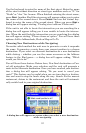
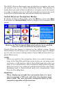
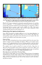
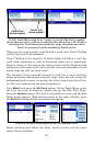
Navigating with the Go To Cursor command. At left, the boater has
selected a waypoint (fish symbol) with the cursor and started navigat-
ing. The figure at right shows the straight-line navigation course after
the cursor and toolbar have been cleared from the screen.
The Go To Cursor command is extremely powerful because it's not lim-
ited to waypoints — it can navigate you to any place you can pick out
on the map. It doesn't matter if your destination is a waypoint, a POI, a
landscape feature or just a spot in the middle of a lake. Just move
around the map to find the place, then use the same commands above
(starting with step 2) to select and go to it.
Following Navigation Indicators
Your iWAY provides a slightly different set of steering indicators in
point-to-point mode. The map still moves as you travel. The black cur-
rent position arrow still points in the direction you are headed. But, the
textual and audible turn instructions are gone.
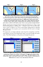
Course Line
Text and audio instructions have been replaced with the red course line,
which is shown in the preceding two figures. When you navigate some-
where, an "S" symbol is placed at your starting position, and your desti-
nation is highlighted. The course line connects the start and destination.
The simplest way to guide yourself is to zoom in closely, then steer so
that the current position arrow moves along the course line. When you
reach your destination, remember to tell the unit to stop navigating.
Press the
MENU key and select the CANCEL NAVIGATION button.
Steering Arrow and other Overlay Data
As in turn-by-turn mode, you can display different types of navigation
information as Overlay Data. Some overlay categories do not work the
same in point-to-point mode, but there are several data types that will
help you steer in roadless areas. One of the easiest to use is the Steer-
ing Arrow overlay.