


72
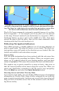
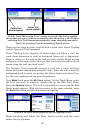
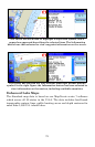
The cursor has been used to highlight a shipwreck symbol, and a
popup box appeared describing the selected item. The Information
button was then selected to view waypoint information on the wreck.
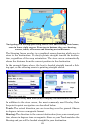
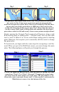
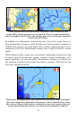
The cursor has selected the Port Aransas Municipal Harbor marina
symbol. In the right figure the Information button has been selected to
view information on the marina, including available amenities.
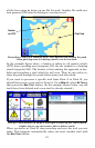
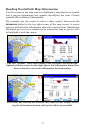
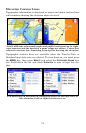
Enhanced Lake Maps
The Standard map data is based on our MapCreate series 7 software
which covers all 50 states in the U.S.A. The data includes land-based
topographic contour lines, public hunting areas and depth contours for
more than 3,000 U.S. inland lakes.