


Page C-2 500 SERIES INSTALLATION MANUAL
Rev G P/N 190-00181-02
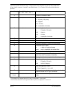
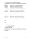
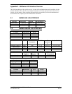
The following table describes the Type 1 output sentence item designator (id) and item data (dddd) fields.
If data for these sentences is invalid or unavailable, dashes ("-") are used to fill in all non-blank character
positions.
* The altitude is not output if the RS-232 port is configured as “Avtn no alt”.
* The line feed character is not output if the RS-232 port is configured as “Avtn no alt”.
Ident (1 byte) Data (10 bytes)
1 2 3 4 5 6 7 8 9 0
Description
z
a a a a a
Current GPS altitude in feet *
A
s d d m m h h
Current latitude, where:
s - N (north) or S (south)
dd - degrees
mm - minutes
hh - hundredths of minutes
B
s d d d m m h h
Current longitude, where:
s - E (east) or W (west)
ddd - degrees
mm - minutes
hh - hundredths of minutes
C
d d d
Track in whole degrees
D
s s s
Ground speed in knots
E
d d d d d
Distance to waypoint in tenths of nautical miles
G
s n n n n
Cross track error, where:
s - L (left) or R (right) of course
nnnn - error in hundredths of nautical miles
I
d d d d
Desired track in tenths of degrees
K
c c c c c
Destination waypoint identifier (will be blank filled on
right if less than 5 characters in identifier)
L
d d d d
Bearing to destination waypoint in tenths of degrees
Q
s d d d
Magnetic variation, where:
s - E (east) or W (west)
ddd - tenths of degrees
S
- - - - f
Nav valid flag status, where:
f - N (nav flagged) or - (nav valid)
T
- - - - - - - - -
Warnings status, only data transmitted are dashes (-).
Used to indicate end of Type 1 sentences.
l (lower case
Lima)
d d d d d d
Distance to destination waypoint in tenths of nautical
miles.