


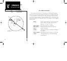
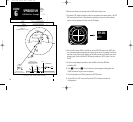
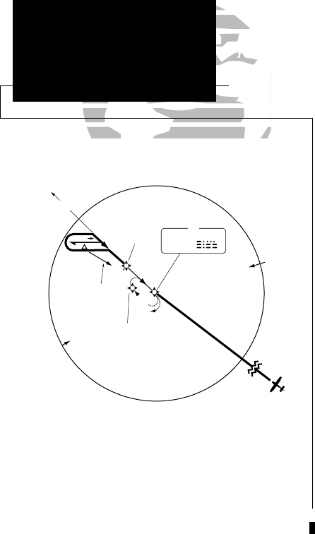
GPS APPROACH EXAMPLES
In the examples that follow, the GPS waypoints are shown along the approach
path. In some cases, intermediate database waypoints have been added to approach-
es. These waypoints are named using lower case letters using the following conven-
tion (the most common database waypoints are defined below). Note that these way-
points are not charted on NOS approach plates. They do appear on current Jeppesen
approach charts.
• dyyyj— DME arc waypoint where yyy is the radial from the
reference facility (VOR) and j represents the arc
radius (e.g., “a”= 1 nm, “b”= 2 nm)
• cfxx or cfxxx— course fix for runway xx or radial xxx
• ffxx or ffxxx— final approach fix for runway xx or radial xxx
• rwxx— runway xx threshold
• nxxhp— NDB approach runway xx intermediate holding pat-
tern waypoint
• maxx or maxxx— missed approach point for runway xx or radial xxx
• vxxhp— VOR approach runway xx intermediate holding
pattern waypoint
84
APPROACH NAVI-
GATION
GPS APproach
SECTION
6
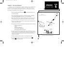
APPROACH NAV
GPS Approach Examples
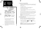
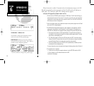
BAY CITY
IAF
344 BYY
307°
10 NM
082°
262°
MAGUS
307°
1800
116° (7.9)
n13hp
ff13
387
Ref: NDB RWY 13 approach
at Bay City TX (3R1)
300 7/14/98 8:50 AM Page 84