


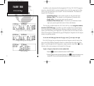
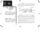

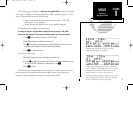
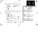


The GNC 300 position page displays your present latitude and longitude,
altitude and a reference waypoint field; and is also used to enter the altimeter setting
during approach operations. The altitude and reference waypoint fields are selectable
to configure the page to your own preferences and current navigation needs.
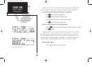
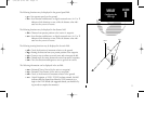
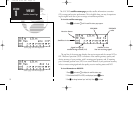
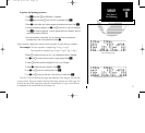
The altitude field can display either the present altitude, minimum safe altitude
(MSA) or enroute safe altitude (ESA). MSA is the recommended minimum altitude
within a ten mile radius of your present position. ESA is the recommended minimum
altitude within a ten mile radius of your course on an active route or direct-to. MSA
and ESA altitudes are calculated from information contained in the database and gen-
erally include mountains, buildings and other permanent features (see left).
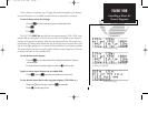
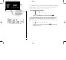
To change the altitude field:
1. Press
C
twice to obtain a flashing cursor in the GPS window.
2. Rotate
O
until the ‘alt/ESA/MSA’ field is highlighted.
3. Rotate
K
to display the desired data. Press
C
to return to normal navigation.
14
REFERENCE
CDI Page
Position page displaying MSA.
The same position page displaying ESA. MSA and
ESA are computed based on data stored in the
NavData card. This information cannot be solely
relied upon as an absolute measure of safe altitude
in your area, particularly if the data card is out of
date. Consult current charts and NOTAMS for
more complete information.
Altitude, MSA or ESA
Position (lat/lon)
Proximity Field
SECTION
1
NAV KEY
Position Page
Altimeter Setting
(during approach navigation)
300 7/14/98 8:49 AM Page 14