


5-13190-00601-02 Rev. B
Garmin G600 Pilot’s Guide
Foreword
Sec 1
System
Sec 2
PFD
Sec 3
MFD
Sec 4
Hazard
Avoidance
Sec 5
Additional
Features
Sec 6
Annun.
& Alerts
Sec 7
Symbols
Sec 8
Glossary Appendix A
Appendix B
Index
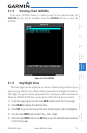
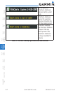
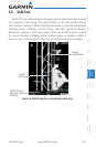
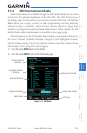
5.4 Safe Taxi
SafeTaxi™ is an enhanced feature that gives greater map detail when zooming
in on airports at close range. The airport display on the map reveals runways
with numbers, taxiways with identifying letters/numbers, and airport landmarks
including ramps, buildings, control towers, and other prominent features.
Resolution is greater at lower map ranges. When the aircraft location is within
the screen boundary, including within SafeTaxi ranges, an airplane symbol is
shown on any of the navigation map views for enhanced position awareness.
Taxiway
Identification
Aircraft
position
DCLTR Soft Key
Removes Taxiway
Markings
Figure 5-9 SafeTaxi Depiction on the Navigation Map Page