


viii
Garmin G600 Pilot’s Guide
190-00601-02 Rev. B
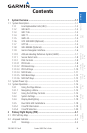
ForewordSec 1 System
Sec 2
PFD
Sec 3
MFD
Sec 4
Hazard
Avoidance
Sec 5
Additional
Features
Sec 6
Annun.
& Alerts
Sec 7
Symbols
Sec 8
GlossaryAppendix A
Appendix B
Index
2.2.2 Reference Speeds ..................................................................2-5
2.3 Attitude Indicator ..................................................................................2-5
2.3.1 Extreme Attitude ...................................................................2-7
2.4 Altimeter ..............................................................................................2-8
2.4.1 Setting the Altitude Bug/Altitude Alerting ...............................2-9
2.4.2 Changing Barometric Setting ...............................................2-10
2.5 Vertical Speed (V/S) Indicator ..............................................................2-10
Setting the Vertical Speed Indicator Bug ................................................2-11
2.6 Horizontal Situational Indicator ...........................................................2-12
2.6.1 Setting the Heading Bug ......................................................2-13
2.6.2 Turn Rate Indicator ..............................................................2-14
2.7 Course Deviation Indicator ..................................................................2-14
2.7.1 Changing CDI Sources .........................................................2-15
2.7.2 Changing CDI Course ..........................................................2-16
2.7.3 Vertical Deviation Indicator (VDI) .........................................2-16
2.7.4 Auto-Slewing ......................................................................2-17
2.8 Supplemental Flight Data ....................................................................2-19
2.8.1 Bearing Pointers ..................................................................2-19
2.8.2 Temperature Display ............................................................2-21
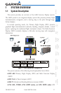
3 Multi-Function Display (MFD) ..............................................................3-1
3.1 Functional Display Map .........................................................................3-2
3.2 MFD Soft Key Map ................................................................................3-3
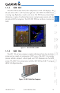
3.3 Navigation Map Pages ..........................................................................3-4
3.3.1 Default Navigation Page ........................................................3-5
3.3.2 Editing Information ................................................................3-5
3.3.3 Selecting Page Options ..........................................................3-5
3.3.4 Changing the Navigation Map Range ....................................3-5
3.3.5 Decluttering Map Pages .........................................................3-6
3.3.7 Selecting Items on the Map ...................................................3-9
3.3.8 Measuring Distances ...........................................................3-10
3.3.2 Customizing Navigation Map Pages .....................................3-11
3.3.3 Map Setup ..........................................................................3-11
3.3.3.1 Map Feature Options ...........................................................3-13
3.3.3.2 Weather Feature Options (Optional) .....................................3-28
3.3.3.3 Traffic Feature Options (Optional) .........................................3-32
3.3.3.4 Aviation Feature Options .....................................................3-33
3.4 Aux Mode Pages .................................................................................3-46