


x
Garmin G600 Pilot’s Guide
190-00601-02 Rev. B
ForewordSec 1 System
Sec 2
PFD
Sec 3
MFD
Sec 4
Hazard
Avoidance
Sec 5
Additional
Features
Sec 6
Annun.
& Alerts
Sec 7
Symbols
Sec 8
GlossaryAppendix A
Appendix B
Index
4.2.2.1 Changing the altitude display mode: ....................................4-10
4.2.3 TAS Symbology ....................................................................4-11
4.2.4 Traffic System Status ............................................................4-12
4.2.5 Traffic Pop-Up......................................................................4-14
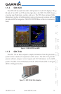
4.3 TIS Traffic (Optional) ............................................................................4-15
4.3.1 Traffic Map Page..................................................................4-15
4.3.1.1 Displaying traffic on the Traffic Map Page .............................4-16
4.3.2 TIS Symbology .....................................................................4-17
4.3.3 TIS Limitations .....................................................................4-18
4.3.4 TIS Alerts .............................................................................4-20
4.3.5 TIS System Status ................................................................4-21
4.3.5.1 Switching Between TIS Operating Modes .............................4-22
4.4 XM Weather (Optional) .......................................................................4-24
4.4.1 Using XM Satellite Weather Products ...................................4-24
4.4.2 Customizing the XM Weather Map ......................................4-24
4.4.3 XM Weather Symbols and Product Age ................................4-27
4.4.4 Weather Legends ................................................................4-29
4.4.5 NEXRAD .............................................................................4-30
4.4.5.1 Reflectivity ..........................................................................4-31
4.4.5.2 NEXRAD Limitations ............................................................4-32
4.4.5.2 NEXRAD Data Viewing Range ..............................................4-33
4.4.6 Echo Tops ............................................................................4-34
4.4.7 Cloud Tops ..........................................................................4-36
4.4.8 XM Lightning ......................................................................4-38
4.4.9 Cell Movement ....................................................................4-39
4.4.10 SIGMETs and AIRMETs ........................................................4-41
4.4.11 METARs ..............................................................................4-43
4.4.12 Surface Analysis and City Forecast ........................................4-45
4.4.13 Freezing Level......................................................................4-48
4.4.14 Winds Aloft .........................................................................4-50
4.4.15 County Warnings .................................................................4-53
5 Additional Features (Optional) ............................................................5-1
5.1 Viewing Charts .....................................................................................5-2
5.1.1 Chart Panning .......................................................................5-3
5.1.2 Choosing a Chart for the Current Airport ................................5-4
5.1.3 Selecting a Chart by Identifier ................................................5-5
5.1.4 Selecting a New Chart by FPL, NRST, or RECENT .....................5-6