


Page 126
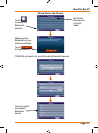
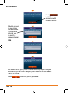
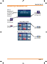
How Do I Use It?
6: Glossary
2D/3D GPS reception
The GPS receiver uses satellite signals to calculate its (your) position and
need at least four signals to give a three-dimensional position, including
elevation. Because the satellites are moving and because objects can
block the signals, your GPS device might not receive four signals. If three
satellites are available, the receiver can calculate the horizontal GPS
position but the accuracy is lower and the GPS device does not give you
elevation data: only 2D reception is possible.
Active route
The currently navigated route. You can save and load routes in TRAX436,
but only one route can be active at any given time, and it is always active
until you delete it, reach your destination or you quit TRAX436. See also:
Route.
City Centre
The City Centre is not the geometric centre of the settlement but an
arbitrary point the map creators have chosen. In towns and villages, it is
usually the most important intersection; in larger cities, it is an important
intersection.
GPS accuracy
Several factors have impact on the deviation between your real position
and the one given by the GPS device. For example, signal delay in the
ionosphereorreectingobjectsneartheGPSdevicehaveadifferent
and varying impact on how accurately the GPS device can calculate your
position.
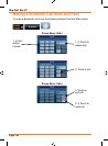
Map
TRAX436 works with digital maps which are not simply the computerised
versions of traditional paper maps. Similarly to the paper road maps, the
2D mode of digital maps show you streets, roads, and elevation is also
shown by colours. In 3D mode, you can see the altitude differences, for
example valleys, mountains and elevated roads.
You can use digital maps interactively: you can zoom in and out (increase
or decrease the scale), you can tilt them up and down, and turn them
left and right. In GPS-supported navigation, digital maps facilitate route
planning.