


2-8 Raychart 320 Chartplotter
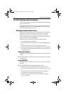
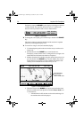
Each time you press the RANGE key, the display scale changes to the next
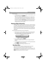
available setting. The status bar, shown in Figure 2-7, indicates the
distance from top to bottom of the screen, in nautical miles.
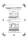
Figure 2-7: Status Bar
➤ To change the scale rapidly, press and hold top or bottom of the RANGE
key.
The distance indicator at the left-hand side of the status bar is updated
whenever you change the display scale.
➤ To zoom in to a larger-scale (more detailed) display:
1. Use the trackpad to position the cursor in the area you wish to see in
larger scale.
2. Press the bottom of the
RANGE key to zoom into the area.
The display, centered on the cursor, is enlarged to show a larger scale
and the distance indicated in the status bar is updated.
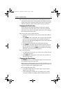
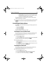
3. If further chart detail is available, using the current chart card you can
press the bottom of the
RANGE key to zoom in further, first re-posi-
tioning the cursor if required. An area of further chart detail is indi-
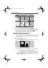
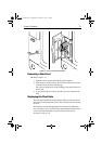
cated by a box around the area as shown in Figure 2-8.
Figure 2-8: Chart Detail Boundaries
4. When the bottom of the RANGE key is pressed and no further chart
detail is available, the result depends on whether Plotter Mode is on
or off as follows:
• If Plotter Mode is Off, the chart scale remains unchanged, ie.
the smallest chart scale is displayed.
VES 43°27^05N
POS 001°02^83W
6nm
D4902-1
SOG 23.4kts
COG 234°M
SCREEN FIND SHIP
CSR 50°50^05W SOG 23.4kn
POS 001°06^00W COG 234°M
6nm
D4907-1
GOTOROUTE
Chart Boundary -
indicates further
detail is available inside
81167_3.BOOK Page 8 Wednesday, November 21, 2001 2:12 PM