


4-10 Raychart 320 Chartplotter
Plotter Mode
Plotter Mode enables you to zoom into a smaller area, even when no chart
data is available for that scale. This allows you use the chartplotter
functions at large scales even when a chart card is not installed.
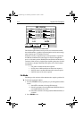
Chart Orientation
The chart is normally North Up, but can be changed to Course Up or
Head Up if heading data is available. The orientation modes give the
following displays:
• North Up: The screen is displayed with north upwards. As you
change heading, the ship’s heading marker moves. This is the default
mode and is the only mode available if there is no heading data.
• Course Up: The chart is stabilized and displayed with the currently
selected course upwards. If you select a new course, the picture
rotates to display the new course upwards.
The reference used for the Course Up depends on the information
available. The first available in the following is used:
• A locked heading over a SeaTalk connection
• The heading at the time Course Up was selected
To update the Course Up reference whilst Course Up is the current
mode, re-select Course Up from the set up menu.
• Head Up: The display shows the vessel’s current heading upwards.
As the heading changes the image will rotate.
Object Information
You can set Object Information ON or OFF. When set ON, object
information is displayed in normal chartplotter operation when the cursor
is placed over a chart object for two seconds. When set
OFF, no
information is displayed.
Waypoint Symbols
This setting controls whether or not the waypoints are shown on the
display, with their appropriate symbols. The active waypoint, and
waypoints in the current route, are always shown.
Waypoint Numbers
This setting controls whether or not the waypoint numbers are shown for
any waypoints in the current route.
81167_3.BOOK Page 10 Wednesday, November 21, 2001 2:12 PM