


Chapter 3: Operation 3-1
Chapter 3: Operation
3.1 Introduction
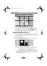
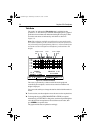
This chapter explains how to navigate with the Raynav 300 GPS Plotter.
It covers the following topics:
• Using electronic chart cards.
• Controlling waypoints, including placing, moving, editing and delet-
ing waypoints.
• Changing the display mode.
• Using a range of data pages to display navigation data.
• Maintaining a Data Log of Time, Position, Course Made Good
(CMG) and Distance Made Good (DMG).
• Working with waypoints and routes, including creating a new route,
managing routes using the Route List and editing routes.
• Following routes and going to waypoints.
• Transferring waypoints and routes
• Saving/Loading waypoints and routes to/from C-Map User Card.
• Using tracks, including showing tracks, track set up, saving tracks
and converting a track to a route (SmartRoute).
• Using the Man Overboard (MOB) feature.
• Setting up Alarms and Timers.
• Cursor echo from other equipment.
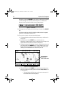
These chart functions are available in plotter mode, so you can plot and
track routes at large scales even when a chart card is not installed.
CAUTION:
The Chartplotter makes it easy to place a waypoint and travel
towards it. However, you should always check first that the route is
safe. When using the Chartplotter in combination with a SeaTalk
autopilot, the autopilot will prompt for confirmation before it steers
the vessel towards the waypoint.
If you have entered your route using a small-scale chart, zoom in to a
larger scale to check for hazards, such as small shoals, that may not be
shown on the smaller scale charts.
Note: Until you are familiar with interpreting the chart display, you
should take every opportunity to compare the displayed objects with vi-
sual targets, such as buoys and coastal structures. You should practice
harbour and coastal navigation during daylight and in clear weather
conditions.
81167_3.BOOK Page 1 Wednesday, November 21, 2001 2:12 PM