


160
Control systems
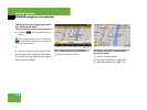
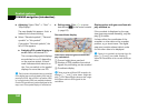
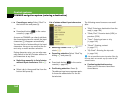
COMAND navigation (introduction)
̈ Adjusting: Select “Navi” Ǟ “Navi” Ǟ
“Map Display”.
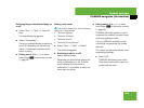
The map display list appears. A dot R
indicates the current setting.
̈ Select “Standard symbols”, “Personal
symbols” or “No symbols”.
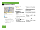
If you select “Personal symbols”, the
list of POIs appears.
̈ Switching POI symbol display on
or off: Select the desired POI.
The corresponding symbol displays
are switched on or off, depending
on the previous status. A check-
mark indicates which status is ac-
tive. You can switch on the symbol
displays for more than one POI.
̈ Exiting menu: Slide omp or press
back button L in the center console
(
୴ page 82).
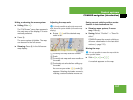
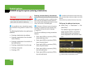
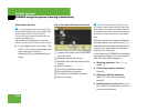
Geo-coordinate display
Illustration: map with geo-coordinate dis-
play switched on
1 Current height above sea level
2 Number of GPS satellites from which
signals for positioning can be received
3 Coordinate display
Display options with geo-coordinate dis-
play switched on
If the crosshair is displayed on the map
view (map was moved manually), only dis-
play 3 is visible.
It shows either the coordinates of the
crosshair or other data on the crosshair
position, e.g. a street name. The digital
map must contain relevant data in order
for this other data to be displayed.
i
The list shows all symbols that are contained
in the digital map across all states (USA) and/or
provinces (CDN). Not all POIs in all states (USA)
or in all provinces (CDN) are available, however.
Certain POI symbols may not be displayed on the
map, even if the symbol display is switched on.
i
There must be sufficient GPS reception for
displays 1, 2 and 3 to be shown. Height dis-
play 1 is an approximation because the naviga-
tion system uses the GPS signals for the
calculation.
i
If there is no crosshair on the map view, dis-
plays 1, 2 and 3 are visible. Display 3
shows the coordinates of the current vehicle po-
sition.