


158
Control systems
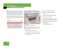
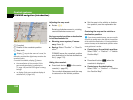
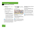
COMAND navigation (introduction)
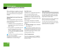
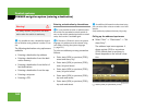
1 Crosshair
2 Details of the crosshair position
3 Map scale
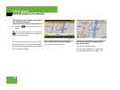
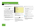
Adjusting the map scale
̈ Rotate ymz.
Rotating clockwise zooms in, rotating
counterclockwise zooms out.
Saving crosshair position as destination
in last destinations list
̈ Showing menu system, if neces-
sary: Press n.
̈ Saving: Select “Position” Ǟ “Save Po-
sition”.
COMAND saves the crosshair position
as a destination in the last destinations
list (
୴ page 213).
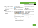
Hiding the crosshair
̈ Press back button L in the center
console (
୴ page 82).
The crosshair disappears and the map
is centered on the vehicle position.
or
̈ Set the map to the vehicle or destina-
tion position, see the explanation be-
low.
Centering the map on the vehicle or
destination position
̈ Centering on the vehicle’s position:
Select “Navi” Ǟ “Position” Ǟ “Vehicle
Position Map”.
or
̈ Press back button L when the
crosshair is displayed.
̈ Centering on the destination:
Select “Navi” Ǟ “Position” Ǟ “Destina-
tion Position Map”.
i
Display 2 may be the name of a road, for
example, provided the digital map contains the
necessary data.
If no data is available, display 2 shows:
ț the coordinates of the crosshair if the
geo-coordinate display is switched on
(
୴ page 160) and the GPS signal is strong
enough
ț no display if the geo-coordinate display is
switched off (୴ page 160)
i
If you have moved the map, you can use this
function to rapidly return the map to the position
of the vehicle or destination. It is only possible to
center the map on the destination position when
route guidance is active.