


Magellan MAP 410 GPS Receiver 63
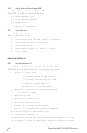
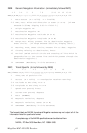
RMB Generic Navigation Information (immediately follows RMC)
1 2 3 4 5 6 7 8 9 10 11 12 13 14
RMB,A,X.XX,a,c--c,c--c,1111.11,a,yyyyy.yy,a,x.x,x.x,x.x,A *hh
1 Data Status (A = valid, V = invalid)
2-3 XTE, naut. miles and direction to steer (L or R) [If XTE
exceeds 9.99 NM, display 9.99 in field 2.]
4 Origin waypoint ID
5 Destination waypoint ID
6-7 Destination Waypoint Latitude (N or S)
8-9 Destination Waypoint Longitude (E or W)
10 Range naut. miles, present fix to destination waypoint
Great Circle. [If range exceeds 999.9 nm, display 999.9.]
11 Bearing, True, Great Circle, Present fix to dest. waypoint
12 Closing velocity to destination, knots
13 Arrival (OR’ed arrival circle and crossing of line which is
perpendicular to the course line and which passes through the
destination waypoint.)
14 CHECKSUM (Mandatory in this sentence.)
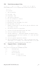
RMC Transit Specific (to be followed by RMB)
1 2 3 4 5 6 7 8 9 10
RMC,hhmmss.ss,A,1111.11,a,yyyyy.yy,a,x.x,x.x,xxxxxx,x.x,a *hh
1 Time, UTC of position fix
2 Status (A = valid, V = Navigation receiver warning)
3-4 Latitude at UTC time, N or S
5-6 Longitude at UTC time, E or W
7 Speed over ground, knots
8 Course over ground, degrees
9 Date (DDMMYY)
10 Magnetic variation, degrees
11 Magnetic variation, sense (E or W)
12 CHECKSUM (Mandatory in this sentence)
The formats listed are NMEA formats and Magellan receivers may not output all of the
information listed for a particular format.
A complete copy of the NMEA specifications can be obtained from:
NMEA, PO Box 3435 New Bern, NC 28564-3435