


24 Magellan MAP 410 GPS Receiver
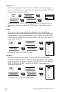
Routes
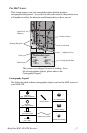
Routes will be displayed on the MAP screen as a black line for each leg,
separated by the icons representing the waypoints that make up the legs of
the route.
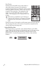
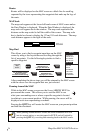
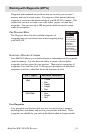
MAP Scale
The map scale appears at the lower left hand corner of MAP screen unless
the Data Window is displayed. When the Data Window is displayed, the
map scale will appear above the window. The map scale represents the
distance on the map scaled to half the width of the screen. The map scale
bar is shaded as shown to display the 1/2 and 1/4 scale distances. The map
scale distance appears to the right of the scale.
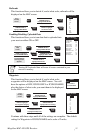
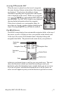
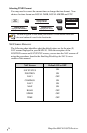
Map Find
This allows you to find a waypoint anywhere on the MAP
screen by using a few keystrokes and scrolling through the
list of waypoints. Use the following keystrokes to find a
specific waypoint:
After completing the above steps you will be returned to the MAP screen
with the cursor over the waypoint that was just selected.
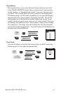
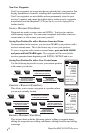
Panning Around the MAP
While in the MAP screen you can use the 8-way ARROW KEYS to
pan around the screen. This allows you to scan the MAP to see
what your surroundings are or where a specific waypoint is located
in relation to your current position. While panning, the cursor will be
displayed as an icon representing crosshairs.
Pressing the QUIT key will center the MAP screen on your present position
and hide the crosshairs.
10 mi
From the
Map
screen.
ENTER
MARK
ENTER
MARK
MENU
Use UP/DOWN
ARROW KEYS to
highlight your choice.
ENTER
MARK
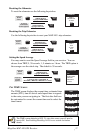
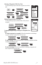
Use UP/DOWN
ARROW KEYS to
highlight MAP SETUP.
Use UP/DOWN ARROW
KEYS to highlight
the ORIENTATION setting.
MENU
HIDE DATA
TRACK HIST
CLR TRACK
MAP SETUP
MAP FIND
WAYPOINTS
ROUTES
SETUP
SUN/MOON
FISH/HUNT
CONTRAST
ALARM/MSG
When panning around the MAP screen, the screen orientation will lock
into its current setting, as was designated in SETUP, and will unlock by
pressing the QUIT key or exiting and returning back to the MAP screen.