


Magellan MAP 410 GPS Receiver 17
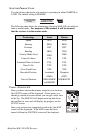
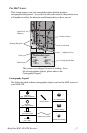
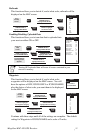
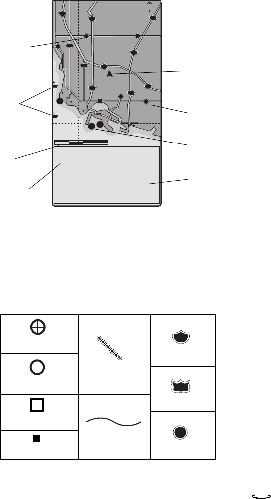
THE MAP SCREEN
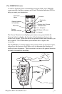
This screen depicts your last computed position plotted against a
cartographic background. As you move with your receiver, the position icon
will update to reflect the direction and distance that you have moved.
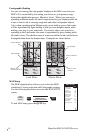
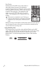
Cartography Legend
The following table outlines cartographic objects used on the MAP screen of
your MAP 410.
1
710
Long Beac
107
Palos Verdes Estates
Lomita
Los
Lawndale
Hawthorne
Compton
710
710
Lt
Lt
TO:
ARROWHEAD COVE
BRG
COG
DST
SOG
134
137
23.1
16.1
N
M
°
M
°
M
K
T
12 mi
Segundo
Torrance
405
Carson
Signal Hill
405
Rancho Palos Verdes
213
Hermosa Beach
Manhattan Beach
405
91
91
Lt
1
1
Lt
Lt
San Pedro
Cerritos Channel
110
110
Gardena
47
N
Floating Waypoint
Lighthouse Icon
Position Cursor
Navigational Data
State/Local
Highway
Local Road
This screen was enlarged for ease of reading. For a
list of cartographic objects, please refer to the
Cartography Legend.
Destination
Scale
Small City
(pop. <20K)
Medium City
(pop. 20K to 100K)
Large City
(pop. 100K to 500K)
Major City
(pop. >500K & Capitals)
Railroad Tracks
State/Country Border
Federal Highway
710
Interstate Highway
91
State/Local Highway
101