


Magellan MAP 410 GPS Receiver 21
Railroads
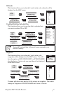
This function allows you to decide if, and at what scale, railroads will be
displayed on the MAP screen.
Enabling/Disabling Uploaded Data
This function allows you to turn data that is uploaded into
your receiver either ON or OFF.
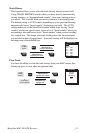
Waypoints
This function allows you to decide if, and at what scale,
waypoints will be displayed on the MAP screen. You will
have the options of OFF, ICONS ONLY or ICONS/NAMES
plus the choice of what scale you want them to be displayed
on the MAP screen.
Continue with these steps until all of the settings are complete. The default
setting for Waypoints is ICONS/NAMES and a scale of 2 miles.
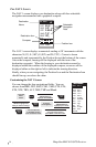
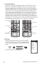
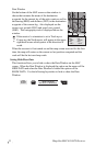
MAP SCALES
OFF
0.1
0.3
0.5
0.8
1
2
5
8
10
20
50
200
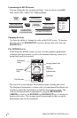
From
the Map
screen.
MENU
Use UP/DOWN
ARROW KEYS to
highlight MAP SETUP.
ENTER
MARK
ENTER
MARK
ENTER
MARK
Use UP/DOWN
ARROW KEYS to
highlight RAILROAD.
Use UP/DOWN ARROW
KEYS to highlight
the desired scale.
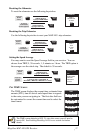
From
the Map
screen.
MENU
Use UP/DOWN
ARROW KEYS to
highlight MAP SETUP.
ENTER
MARK
Use UP/DOWN ARROW
KEYS to highlight
the waypoint category.
ENTER
MARK
Use UP/DOWN
ARROW KEYS to
highlight the icon setting.
ENTER
MARK
Use UP/DOWN
ARROW KEYS to
highlight the Map scale.
ENTER
MARK
WPT NAMES
OFF
ON
USER
OFF
ICONS ONLY
ICONS/NAMES
MAP SCALES
0.1
0.2
0.3
0.5
0.8
1
2
5
8
10
20
50
200
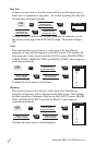
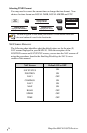
Turning OFF uploaded data will erase all routes contained in your
receiver’s memory.
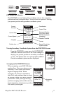
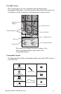
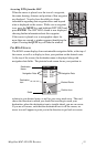
MAP SETUP
ORIENTATION NORUP
COURSE PROJ OFF
LAT/LON GRID ON
MAP TEXT ON
MAJOR CITIES 300
LARGE CITIES 200
MEDIUM CITIES 50
SMALL CITIES 8
MAJOR HWY 120
STATE/LOCAL HWY 80
LOCAL ROADS 50
RAILROADS OFF
UPLOADED DATA OFF
From the
Map
screen.
ENTER
MARK
ENTER
MARK
MENU
Use UP/DOWN
ARROW KEYS to
highlight ON or OFF.
ENTER
MARK
Use UP/DOWN
ARROW KEYS to
highlight MAP SETUP.
Use UP/DOWN ARROW
KEYS to highlight
the UPLOADED DATA.
A confirmation/
warning screen
appears.
Use UP/DOWN
ARROW KEYS to
highlight YES or NO.
ENTER
MARK