


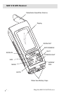
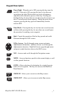
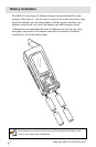

Magellan MAP 410 GPS Receiver 9
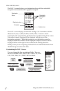
SELECTING PRIMARY USAGE
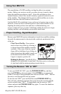
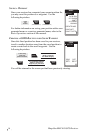
You can choose what mode your receiver is operating in, either MARINE or
LAND. The default setting is MARINE.
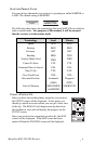
The following chart shows the terminology that your MAP 410 uses while in
land or marine mode. For purposes of this manual, it will be assumed
that the receiver is in the marine mode.
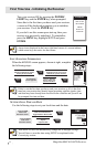
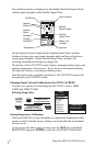
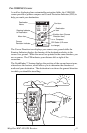
TAKING A POSITION FIX
Once you have chosen the primary usage for your receiver,
the STATUS screen will be displayed. At this point, you
should go outside in an area where you can get a clear view
of the sky. The MAP 410 will begin receiving data from
the satellites in view and will display the progress on the
STATUS screen.
Once your receiver has computed a position fix, the MAP
screen will be displayed. If the MAP screen has been
turned off then the POSITION screen will be displayed.
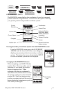
Use the ARROW keys
to toggle between
MARINE and LAND.
ENTER
MARK
During Initialization
at the Preference
screen.
Terminology
Speed
Bearing
Distance
Heading
Velocity Made Good
Course To Steer
Estimated Time of Arrival
Time To Go
Cross Track Error
Recorded Position
Units of Measure
Land
SPD
BRG
DST
HDG
VMG
CTS
ETA
TTG
XTE
Landmark
(LMK)
MILES/MPH
or KM/KPH
Marine
SOG
BRG
DST
COG
VMG
CTS
ETA
ETE
XTE
Waypoint
(WPT)
NM/KNOTS
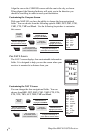
STATUS
3D
12
13
18
7
8
POWER
001112
782385
25
TEMP
25
˚
c
N