


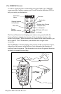

22 Magellan MAP 410 GPS Receiver
1
710
Long Beac
107
Palos Verdes Estates
Lomita
Los
Lawndale
Hawthorne
Compton
710
710
Lt
Lt
TO:
ARROWHEAD COVE
BRG
COG
DST
SOG
134
137
23.1
16.1
N
M
°
M
°
M
K
T
12 mi
Segundo
Torrance
405
Carson
Signal Hill
405
Rancho Palos Verdes
213
Hermosa Beach
Manhattan Beach
405
91
91
Lt
1
1
Lt
Lt
San Pedro
Cerritos Channel
110
110
Gardena
47
N
N
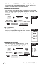
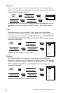
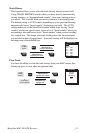
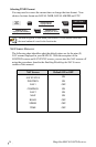
From
the Map
screen.
MENU
ENTER
MARK
Use UP/DOWN ARROW
KEYS to highlight
HIDE DATA or SHOW DATA.
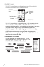
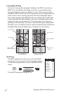
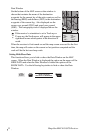
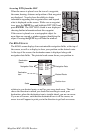
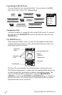
Data Window
On the bottom of the MAP screen a data window is
shown that contains the name of the destination
waypoint for the current leg of the active route as well as
the bearing (BRG) and distance (DST) to the destination
waypoint of the current leg. Also displayed are the
course over ground (COG) and speed over ground
(SOG). The cartography scale is displayed above the
window.
If the receiver’s orientation is set to Track up or
Course up, the North arrow will appear in the upper
right hand corner which points in the direction of
north.
When the receiver is first turned on and the map screen accessed for the first
time, the map will center on the current or last position computed and the
scale will be the last used map scale.
Setting Hide/Show Data
This function allows you to hide or show the Data Window on the MAP
screen. When the Data Window is displayed the option on the menu will be
HIDE DATA and when the Data Window is hidden the option will be
SHOW DATA. Use the following keystrokes to hide or show the Data
Window: