


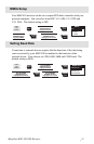

Magellan MAP 410 GPS Receiver 55
COORDINATE SYSTEMS
Positions are locations that are described in a unique way so that one
location cannot be confused with another. This is done by using a coordinate
system to describe locations. Your Magellan receiver has the ability to use
any one of 12 different coordinates systems; LAT/LON (latitude and
longitude), UTM (Universal Transverse Mercator), OSGB, Irish Grid,
Finnish, German, French, MGRS, User Grid, Swiss Grid, TD or Swedish
Grid. The one you select (in SETUP) will be determined by the maps and
charts you use; you would generally want the receiver to display position
coordinates in the same system that is used by your maps.
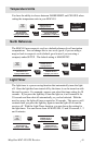
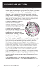
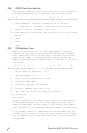
LAT/LON Coordinate System. LAT/
LON is the most commonly used
coordinate system today. It projects lines
of latitude (parallels) and lines of longitude
(meridians) onto the earth’s surface. Lines
of latitude are the equator and the
horizontal lines that are parallel to it. Lines
of longitude are the vertical lines that are
perpendicular to the equator and pass
through the poles. A position is described
as being the intersection of a line of
latitude and a line of longitude.
Specifically, a position is up to 90° north or south of the equator (up to the
poles, which are 90°N and 90°S; the equator is 0° latitude), and up to 180°
east or west of the Prime Meridian, which is 0° longitude. (The Prime
Meridian passes through Greenwich, England.) Parts of a degree are
minutes; there are 60 minutes (written as 60') to a degree. Minutes can also
be divided into smaller units. Fractions of a minute can be expressed as
decimals or as seconds. (There are 60 seconds to one minute, written as
60"). So a LAT/LON position coordinate can be expressed in two ways,
which your Magellan GPS receiver displays as 25°47.50 or 25°47’30.
UTM Coordinate System. Another commonly used coordinate system is
UTM (Universal Transverse Mercator), which is generally found on land-
based maps and quad sheets that are produced by government map
providers. On land, you may find that UTM coordinates are easier to use
than LAT/LON.
UTM coordinates are easy to use, but since the model it is based on is
somewhat abstract, this section is a very simplified introduction to UTM.
E
Q
U
A
T
O
R
0
°
P
R
I
M
E
M
E
R
I
D
I
A
N
0
°
L
a
t
i
t
u
de
L
o
n
g
i
t
u
d
e
115°00.00W
42°30.00N