


Magellan MAP 410 GPS Receiver 25
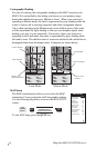
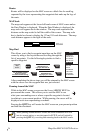
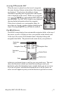
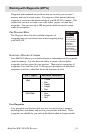
Accessing WPTs from the MAP
When the cursor is placed over the icon of a waypoint,
the name, bearing, distance and position of that waypoint
are displayed. You also have the ability to obtain
information regarding that waypoint above and beyond
what is displayed on the screen. While over a waypoint
icon, press the MENU key and highlight WPT INFO and
press ENTER. The WPT INFO screen is now displayed
showing further information about this waypoint.
If the cursor is placed over a cartographic object for
more than one second, a window appears identifying the
object. Pressing the QUIT key will hide the window.
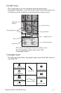
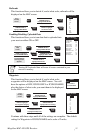
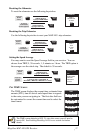
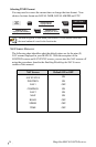
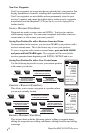
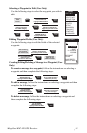
THE ROAD SCREEN
The ROAD screen displays four customizable navigation fields, at the top of
the screen, as well as a display to show your position on the desired route.
At the top of the screen, the destination name is displayed along with
navigation data fields. The pictorial road screen shows your position in
relation to your desired route, as well as your cross track error. The road
shows the direction in which you should be travelling to reach your
destination; when the destination icon is straight ahead, you are on course.
If you are off course, such that the destination icon is off the screen, an
arrow icon will appear to point you in the direction to get back on course.
1
710
Long Beac
107
Palos Verdes Estates
Lomita
Los
Lawndale
Hawthorne
Compton
710
710
Lt
Lt
TO:
ARROWHEAD COVE
BRG
COG
DST
SOG
134
137
23.1
16.1
N
M
°
M
°
M
K
T
12 mi
Segundo
Torrance
405
Carson
Signal Hill
405
Rancho Palos Verdes
213
Hermosa Beach
Manhattan Beach
405
91
91
Lt
1
1
Lt
Lt
San Pedro
Cerritos Channel
110
110
Gardena
47
N
TO: FISH
BRG
127
°
DST
3.52
COG
156
°
SOG
2.7
m
m
n
m
K
T
1.0
Navigation Data
Destination
Icon
Desired Route
Position Icon
Destination
Name
Navigation Data
Scale