


56 Magellan MAP 410 GPS Receiver
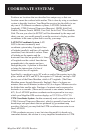
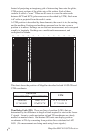
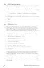
Instead of projecting an imaginary grid of intersecting lines onto the globe,
UTM projects sections of the globe onto a flat surface. Each of these
sections is called a “zone.” There are 60 zones to cover the entire earth
between 84°N and 80°S (polar areas are not described by UTM). Each zone
is 6° wide as projected from the earth’s center.
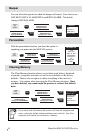
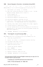
A UTM position is described by three elements; the zone it is in, the easting,
and the northing. Eastings and northings measure how far into a zone a
position is in meters. Eastings are an east/west measurement, and correspond
roughly to longitude. Northings are a north/south measurement, and
correspond to latitude.
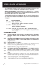
This chart shows the position of Magellan described in both LAT/LON and
UTM coordinates.
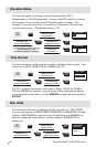
Time Delay Grids (TD). These are lines of position (LOPs) that are
determined by the difference in length of time required to receive the Loran-
C signals. Loran is a radio navigation aid and TD coordinates are clearly
marked on nautical charts. Our marine GPS units can display position
coordinates in TDs by converting from position fixes calculated in LAT/
LON. (No measurements are being made using Loran signals).
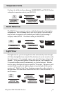
1511 12 13 14
3000 Km
3000 Mi.
Scale at the Equator.
12345
180°
150°
10
120° 90°
20
60°
25
30°
30
0°
35
30°
40
60°
45
90°
50
120°
55
150°
60
180°
0°
NOTE: The area described by the UTM coordinate system extends to 84°N and to 80°S.
6789 16171819 21222324 26272829 31323334 36373839 41424344 46474849 51525354 56575859
34 06’35”N
LAT/LON
DEG/MIN.MM DEG/MIN/SEC
34 06.58N
117 49.56W 117 49’34”W
UTM
11 4 23 818 E
37 74 624 N