


58
Keep adding routes in this way until you have plotted your whole route.
Of course, you don't have to use just one method. You could add a hand-
ful of Aviation Waypoints but in between place some waypoints from
the map, if you want to detour over a particular landmark. Or even in-
clude personal waypoints in your route, if you'd like to fly over a
friend's house. Since you add one waypoint at a time, you can choose
the best way to enter each one.
For another example, we'll go through the process of creating a Land
Mode route using only the map option.
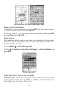
1. From the
NAVIGATION PAGE, press MENU|ENT or from the MAP PAGE,
press
MENU|MENU|↓ to ROUTE PLANNING|ENT.
2. Press
ENT|↓ to (ROUTE END)|ENT|↓ to ADD FROM MAP|ENT. The Map
Page appears with the cursor showing.
3. Use the Zoom keys and arrow keys to move the map and cursor until
the cursor is centered on the spot where you want your route to begin.
(If you are starting at your current position or the current cursor posi-
tion, you are already at the starting spot.)
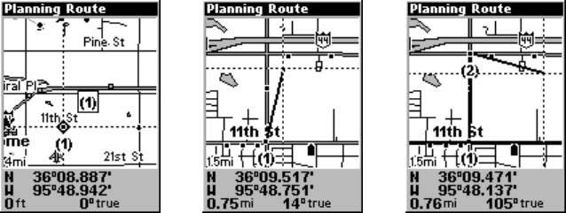
4. Set the first route waypoint: press
ENT. In this example we moved to
the intersection of 11th Street and 145th E. Ave. to start our route to a
public hunting area next to a river.
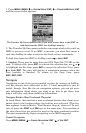
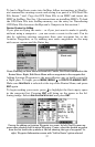
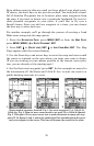
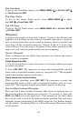
1. 2. 3.
Route creation sequence, from left: Fig. 1. Set route waypoint (1) at 11th St. &
145th Ave. Fig. 2. Zoom in; move cursor north to set point (2) at 145th & Admiral.
Fig. 3. With point (2) set, move cursor east to mark interstate on-ramp with way-
point (3). In figures 2 and 3, notice the rubber band line extending from the previ-
ously set waypoint to the cursor. This line will become the course for the route.