


9
WAAS signals make your GPS navigation even more accurate. Your
AirMap automatically receives both GPS and WAAS signals. However,
WAAS has some limits you should know about.
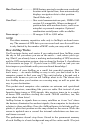
First, the U.S. government has not completed construction of the WAAS
system, so it is not yet fully operational. The ground stations are in
place, but only a few of the needed WAAS satellites have been launched.
WAAS can boost the accuracy of land and marine GPS navigation, but the
system is designed for aircraft. The satellites are in a fixed orbit around
the Equator, so they appear very low in the sky to someone on the ground
in North America. Aircraft and vessels on open water can get consistently
good WAAS reception, but terrain, foliage or even large man-made struc-
tures frequently block the WAAS signal from ground receivers.
You'll find that using your GPS+WAAS receiver is both easy and
amazingly accurate. It’s easily the most accurate method of electronic
navigation available to the general public today. Remember, however,
that this receiver is only a tool. As this manual goes to press, the FAA
has not yet certified any hand-held GPS+WAAS receivers for use as the
sole navigation aid for VFR pilots. Always have another method of
navigation available, such as a sectional chart and your aircraft's mag-
netic and gyro compasses, or a conventional nav/com radio.
Also remember that this unit will always show navigation information
in the shortest line from your present position to an airport, VOR or
other waypoint, regardless of obstacles and terrain! It only calculates
position, it can’t know what’s between you and your destination, for
example. It’s up to you to safely navigate around obstacles and rising
terrain, no matter how you’re using this product.
How to use this manual: typographical conventions
Many instructions are listed as numbered steps. The keypad and arrow
"keystrokes" appear as boldface type. So, if you're in a real hurry (or
just need a reminder), you can skim the instructions and pick out what
menu command to use by finding the boldface command text. The para-
graphs below explain how to interpret the text formatting for those
commands and other instructions:
Arrow Keys
The arrow keys control the movement of dotted cross-hair lines on your
mapping screen called the cursor. The arrow keys also help you move
around the AirMap menus so you can execute different commands.
They are represented by symbols like these, which denote the down ar-
row key, the up arrow, the left arrow and the right arrow: ↓ ↑ ← →.