


ii
E6B Wind Speed/Direction Calculator................................... 43
Vertical Navigation Calculator .............................................. 44
Section 4: Land Operation..........................................................45
Keypad......................................................................................... 45
Power/lights on and off ...............................................................46
Main Menu.................................................................................. 46
Pages ........................................................................................... 46
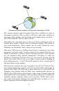
Satellite Status Page .............................................................. 46
Position Page........................................................................... 47
Navigation Page...................................................................... 48
Map Page................................................................................. 49
Moving Around the Map: Zoom & Cursor Arrow Keys.............50
Find Distance From Current Position To Another Location ....50
Find Distance From Point to Point ........................................50
Find Your Current Position........................................................ 51
Icons............................................................................................. 51
Create Icon on Map................................................................. 51
Create Icon at Current Position............................................. 52
Delete an Icon .........................................................................52
Load GPS Data Files from an MMC.......................................... 52
Navigate ......................................................................................53
Navigate Back to Man Overboard Waypoint.........................53
Cancel Navigation...................................................................53
Navigate a Route..................................................................... 54
Navigate to Cursor Position on Map...................................... 54
Navigate to an Icon.................................................................54
Navigate to Point of Interest (POI)........................................54
Navigate to a Waypoint ..........................................................54
Navigate a Trail ......................................................................55
Routes.......................................................................................... 56
Create and Save a Route ........................................................ 56
Delete a Route.........................................................................59
Save GPS Data Files to an MMC............................................... 59
Searching..................................................................................... 60
Switch to Aviation Mode............................................................. 62
Switch Back to Land Mode from Aviation Mode................... 62
Trails ........................................................................................... 62
Create and Save a Trail.......................................................... 62
Delete a Trail ..........................................................................62
Edit a Trail Name ...................................................................63
Transferring GPS Data Files ..................................................... 63
Transferring and Loading Custom Maps ..................................63
Utilities........................................................................................ 63