


1
Section 1: Read Me First!
How this manual can get you flying, fast!
Welcome to the exciting world of GPS! We know you're anxious to take
off and begin navigating, but we have a favor to ask. Before you grab the
batteries and head for the plane, please give us a moment or two to show
you how to skip around our manual for the information you need. (Tips
start on page 2.) We want to help you get the best performance from this
versatile little GPS unit — in the air, on the ground and on the sea!
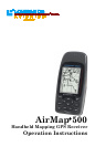
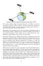
Before we go any further, we want to thank you for buying an AirMap
500. Whether you're a first time GPS user or a professional navigator,
you'll find that the AirMap 500 includes a complete set of powerful
aeronautical mapping and navigation features, yet is easy to use. How
easy? Well, if you've already figured out how to load the card and bat-
teries yourself, and you just can't wait any longer, turn to the Quick
Reference on page 31 and head outside with your AirMap! You can be
practicing touch-and-goes at a nearby airport in only 12 steps.
Not in that big of a hurry? Good, because we really recommend you
practice a bit before taking your AirMap aloft. The AirMap 500 is a true
pocket-sized GPS+WAAS receiver, but its slim silhouette is crammed
with lots of extra features and value. You don't need to learn them all
right away, but a little practice on the ground will help you become fa-
miliar with AirMap's capabilities — and make you a safer pilot. Flying,
of course, is why you bought an AirMap, but it's like having three dif-
ferent GPS receivers in one. Here are the other two reasons why.
Need business or pleasure travel directions or phone numbers after
landing? You don't need another GPS — when you leave the cockpit,
just slip your AirMap into pocket or purse and take advantage of the
fully-functional Land Navigation Mode. With your own custom-built
MapCreate 6 map, your AirMap can use a massive searchable Point
of Interest database of businesses and attractions to lead you to your
final destination. (Land Mode Operation is described in Section 4;
Searching is covered in Section 6.)
And AirMap performance doesn't stop at the water's edge. If your des-
tination is a boating or fishing adventure, your AirMap will help you
safely navigate the Great Lakes and coastal U.S. waters with our
70,000 item database of marine navigation aids, wrecks and obstruc-
tions. (This also requires a MapCreate map; functions are discussed in
Section 4. The MapCreate manual has an Easy Mode Quick Reference
of its own; it'll help you make a map in just 6 steps.)