


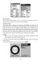
44
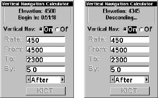
Vertical Navigation Calculator
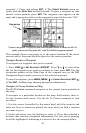
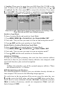
With the Vertical Navigation Calculator, the AirMap 500 can help you de-
cide when to let down for an approach to an airport. In the following exam-
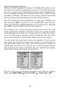
ple, we're travelling to the Wichita Mid-Continent airport in Wichita, Kan-
sas. It’s identifier is shown at the bottom of the screen – KICT. We are
travelling at 4500 feet, and need to be at the pattern altitude (about 2300
feet) by 5 nautical miles from the airport using a 450 fpm descent.
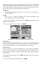
After determining the above information, use ↑ or ↓ to highlight each
field, then press
ENT. In each box, use the arrow keys to enter the data.
When you’re finished, highlight
ON next to the "Vertical Nav" label and
press
ENT. A screen similar to the one below appears.
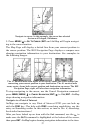
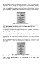
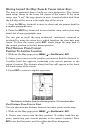
The solution to our vertical navigation problem shows at the top of the
screen. Our current altitude is 4500 feet and at our current airspeed,
we should begin our descent in 51 minutes and 18 seconds. If we main-
tain a 450 fpm descent starting in about 51 minutes, then we should
reach pattern altitude 5 nautical miles before we reach the airport.
You can watch the clock count down your approach. If you increase
your speed, the clock will decrease more quickly. If you slow down, it
will take longer. Either way, when you reach the point at which you
should begin your descent, the box at the top of the screen changes.
Now in place of the timer, it indicates that you should be descending.
Above that, it shows the altitude you should be at.
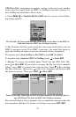
Vertical Navigation Calculator
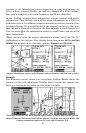
To get to the vertical navigation calculator menu: while in Aviation
Mode, press
MENU|MENU|↓ to UTILITIES|ENT|↓ to VERTICAL NAV |ENT.