


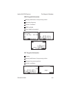


I Icon: A symbol shown on the display depicting present
position. The icon is shown as a symbol of an airplane on
the Apollo 360’s moving map screens.
Identifier: A name, typically abbreviated, assigned to a
waypoint. Theidentifier mayconsist ofnumbers and alpha
characters, up to six in length. For example, the airport
identifier for Los Angeles International Airport is LAX.
Instrument Flight Rules (IFR)
Intersection (INT): A point defined by any combination
of courses, radials, or bearings oftwo ormore navigational
aids.
K Knot (kt): A unit of speed equal to one nautical mile per
hour.
L Latitude (lat): Any line circling the earth parallel to the
equator, measured in degrees, minutes, and seconds north
and south of the equator.
Longitude (lon):Anyline from thenorth tothesouth pole,
measured in degrees, minutes, and seconds of a circle, east
or west of the Prime Meridian (Greenwich, England).
M Magnetic North: The region, some distance from the
geographic north pole where the earth’s magnetic lines
concentrate. A magnetic compass points to the magnetic
north.
Magnetic Variation (Mag Var): The angle between the
magnetic and true north. At various points on the earth it
is different due to local magnetic disturbances. It is shown
on charts as isogonic lines marked with degrees of
variation, either east or west. These degrees must be added
to or subtracted from the true course to get the magnetic
course. (Easterly variations are deducted, and westerly
variations are added.) The Apollo 360 automatically sets
Apollo 360 GPS Receiver Glossary of Navigation Terms
P/N 560-0123-01 A-3