3-19
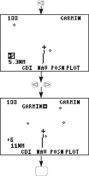
The scale setting is shown in the
bottom left corner.
· Highlight the scale setting field
with the arrow keys and change
the scale setting with CLR. You
may also change the scale settings
with the number keys (0-9).
Finally, you may identify waypoint
shown on the Plot Page.
· Select a scale setting that allows
you to see the destination waypoint
(GARMIN).
· With the arrow keys, highlight the
waypoint shown on the Plot Map.
Once highlighted, the waypoint
name is shown.
Experiment with your GPS 75.
You are on your way to mastering the GPS 75. If you let the simulator
run, you will eventually get a message, “Approaching GARMIN”, just
prior to reaching the waypoint. Press PWR/STAT to view the message;
and again to return to the Plot Page.
You may also want to:
· Press NAV, WPT, GOTO, or any other key to become more familiar
with the available pages.
· Practice using the softkeys and cyclic fields to display new
information.
· Change the simulation speed (faster or slower).
· Read Chapter 6 on Unit Customization and set up the unit to your
preference.
· Stop the simulation. You can stop the simulation by turning the
unit off (press and hold PWR/STAT), or go to the “OP Mode” set up
and change to the “Normal” or “Battery Saver” modes (see Section
6.1).
CLR


