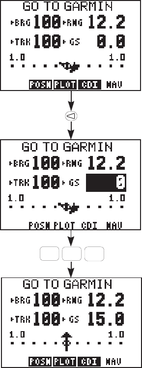
3-16
then displayed.
· Select the NAV Summary Page
with the NAV softkey. Now back
to our trip.
Set the Simulation Speed...
· With the arrow keys move the
cursor to the ground speed field.
(If this field does not currently
indicate “GS”, for ground speed,
highlight that field with the left
arrow key and press CLR until it
does.)
· Enter a ground speed of 15 knots
by pressing “1”, “5”, and ENT. (The
GPS 75 will accept speeds of up to
90 knots.) The simulation speed is
now set and the GPS 75 is
simulating a trip from coordinates
N39° W95° to the “GARMIN”
waypoint (our Lenexa, KS facility).
Examine the Navigation Information...
At this point, you can explore the capabilities of the GPS 75. While you
are on the Navigation Summary Page, you may want to examine other
information not currently displayed (see Section 3.8).
· As the unit is navigating, you will notice the Range (RNG) to
GARMIN decreasing. If you wish to see the distance back to where
you started from, highlight this field (top right) with the arrow
keys, and press CLR until distance made good (DMG) is displayed.
· Highlight the ground speed (GS) field (bottom right) and press
ABC
1
MNO
5
ENT
