3-10
track. The outer lines give a perspective view of the distance to a
waypoint. As the waypoint comes into range, it will be displayed and the
outer lines will become parallel.
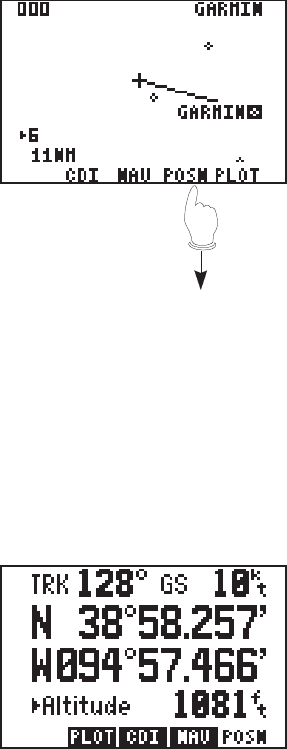
Plot Page
The Plot Page shows a graphic top
view of your course. The destination
waypoint is shown at the top right of
the screen. Your present position is
shown as a plus (“+”) sign in the
middle of the page. The track history
and/or the active route are shown as
a solid line. (Plotting of ground
track and active route is user-
selectable, see Section 6.2.) Nearby
waypoints are displayed as
diamonds. You may view the
waypoint name by scrolling to the point with the arrow keys. A GOTO
may be performed by pressing GOTO while the cursor is on the waypoint.
The scale distance for the screen (distance represented by height of
screen) is at the lower left corner of the screen. The scale number
(directly above the scale distance) may be changed by moving the cursor
to the scale number and pressing CLR, or by entering a new number (0-
9). Finally, the Plot Page can be oriented as a “North up”, “Ground Track
Up”, or “Desired Track Up” display (see Section 6.2).
Position Page
The Position Page is described in
Section 3.3. Please refer to that
section for further information.
· Press the POSN
softkey .


