


A-24 Lassen-SK8 Embedded GPS Module
Trimble Standard Interface Protocol
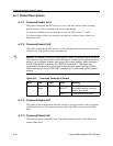
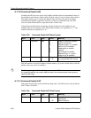
A.17.15 Command Packet 0x31
This packet is identical in content to Packet 0x23. This packet provides an initial position
to the GPS receiver in XYZ coordinates. However, the GPS receiver assumes the position
provided in this packet to be accurate. This packet is used for satellite acquisition aiding in
systems where another source of position is available and in time transfer (one-satellite
mode) applications. For acquisition aiding, the position provided by the user to the GPS
receiver in this packet should be accurate to a few kilometers. For high-accuracy time
transfer, position should be accurate to a few meters.
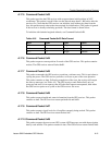
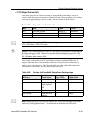
A.17.16 Command Packet 0x32
This packet is identical in content to Packet 0x2B. This packet provides the GPS receiver
with an approximate initial position in latitude, longitude, and altitude coordinates.
However, the GPS receiver assumes the position provided in this packet to be accurate.
This packet is used for satellite acquisition aiding in systems where another source of
position is available and in time transfer (one-satellite mode) applications. For acquisition
aiding, the position provided by the user to the GPS receiver in this packet should be
accurate to a few kilometers. For high-accuracy time transfer, position should be accurate
to a few meters.
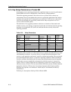
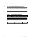
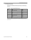
A.17.17 Command Packet 0x35
This packet requests the current I/O option states and optionally allows the I/O option
states to be set as desired.
To request the option states without changing them, the user sends the packet with no data
bytes included. To change any option states, the user includes 4 data bytes with the values.
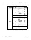
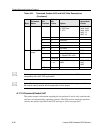
The I/O options, their default states, and the byte values for all possible states are shown
below. These option states are held in battery-backed memory and can be set into non-
volatile RAM (EEPROM) with the 0x8E-26 command. The GPS receiver returns Packet
0x55. See A.3 for information on saving the settings to non-volatile memory.
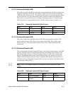
These abbreviations apply to the following table: ALT (Altitude), ECEF (Earth-centered,
Earth-fixed), XYZ (Cartesian coordinates), LLA (latitude, longitude, altitude), HAE
(height above ellipsoid), WGS-84 (Earth model (ellipsoid)), MSL geoid (mean sea level),
and UTC (coordinated universal time).