


Lassen-SK8 Embedded GPS Module C-19
Trimble ASCII Interface Protocol (TAIP)
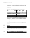
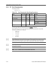
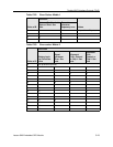
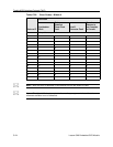
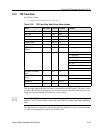
C.17 PV Position/Velocity Solution
Data String Format:
AAAAABBBCCCCCDDDDEEEEEFFFGGGHI
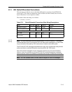
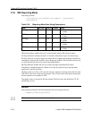
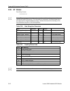
Table C-17. Position/Velocity Solution Data String Descriptions
Position is in latitude (positive north) and longitude (positive east) WGS-84. Heading is in
degrees from True North increasing eastwardly. The GPS time of day is the time of fix
rounded to the nearest second.
*
Note – The data in this message is to be considered invalid and should not be used, if the
Age of Data Indicator is equal to 0 (signifying data not available).
Item # of Char UNITS Format Value
GPS Time of day 5 Sec AAAAA
Latitude 8 Deg BBB.CCC
CC
Longitude 9 Deg DDDD.E
EEEE
Speed 3 MPH FFF
Heading 3 Deg GGG
Source 1 n/a H 0 = 2D GPS
1 = 3D GPS
2 = 2D DGPS
3 = 3D DGPS
6 = DR
8 = Degraded DR
9 = Unknown
Age of Data Indicator 1 n/a I 2 = Fresh, <10 sec
1 = Old, >10 sec
0 = Not available
Total 30