


A-66 Lassen-SK8 Embedded GPS Module
Trimble Standard Interface Protocol
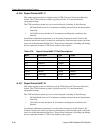
A.18.6 Report Packet 0x8F-17
This packet reports position in single precision UTM (Universal Transverse Mercator)
format. The UTM coordinate system is typically used for U.S. and international
topographical maps.
The UTM coordinate system lays out a world-wide grid consisting of the following:
• 60 North/South zones in 6° increments extending eastward from the International
Date Line
• 10 East/West zones divided in 8° increments extending above and below the
Equator.
Coordinates within these boundaries cover all surface locations from 80° South to 84°
North and encircle the earth. Locations are indicated by offset from the equator and in the
zones east of the International Date Line. These offsets are known as Northing and Easting
and are expressed in meters. UTM is not usable in polar regions.
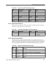
A.18.7 Report Packet 0x8F-18
This packet reports position in double precision UTM (Universal Transverse Mercator)
format. The UTM coordinate system is typically used for U.S. and international
topographical maps.
The UTM coordinate system lays out a world-wide grid consisting of the following:
• 60 North/South zones in 6° increments extending eastward from the International
Date Line
• 10 East/West zones divided in 8° increments extending above and below the
Equator.
Coordinates within these boundaries cover all surface locations from 80° South to 84°
North and encircle the earth. Locations are indicated by offset from the equator and in the
zones east of the International Date Line. These offsets are known as Northing and Easting
and are expressed in meters. UTM is not usable in polar regions.
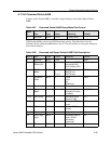
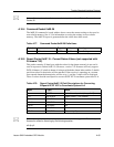
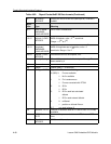
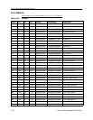
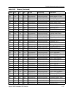
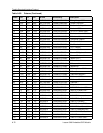
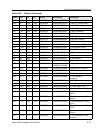
Table A-79. Report Packet 0x8F-17 Field Descriptions
Byte Description Type Value
0 Subcode Byte 0x17
1 Gridzone Designation Char
2-3 Gridzone Integer
4-7 Northing Single Meters
8-11 Easting Single Meters
12-15 Altitude Single Meters
16-19 Clock Bias Single Meters
20-23 Time of Fix Single Seconds