


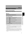

36
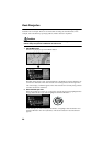
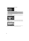
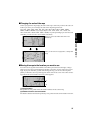
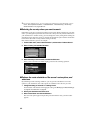
Guidance point*
The next turning point is shown by a yellow flag.
Destination*
The checker-flag indicates your destination
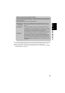
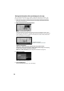
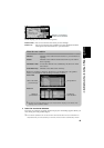
(1) Name of the street you drive next.*
(2) Distance to the guidance point*
(3) Current location
The current location of your vehicle. The arrow shows your heading, and the display moves
automatically as you drive.
(4) Distance to the destination*
(5) Name of the street you are in
(6) Compass
The red arrow shows North.
(7) Map scale indicator
The figure gives the distance represented by the red bar. In Arrow mode and Driver’s view, it
shows the scale of the map displayed on the right-hand side of the screen.
(8) Current time
(9) TMC mark and the name of the broadcasting station
The name of RDS broadcasting station this unit is receiving is shown (where available).
(10) Travelling direction*
(11) Estimated time of arrival (or travel time to your destination)*
(12) Tracking mark
The tracking mark shows the route your vehicle has travelled.
(13) Map of your surroundings*
(14) Distance to an intersection*
It is displayed in Arrow mode and Side arrow mode. The green bar gets shorter as your vehi-
cle approaches an intersection.
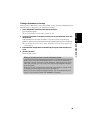
➲ Information with the mark (*) appears only when the route is set.
➲ You can display the current time and estimated time of arrival (or travel time to your desti-
nation) on the screen. For the details of setting, see “Travel Time Display” on page 89.
➲ You can select the method of deleting tracking mark. For the details, see “Tracking Display”
on page 88.
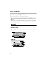
➲ When “Zoom Map of Intersection” (see “Zoom Map of Intersection” on page 87) is set “ON”,
an enlarged map showing the area around an intersection appears as you approach the
intersection (except Driver’s view).
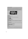
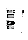
➲ Tracking display shows about 200 km tracking of your vehicle with a white dots. When your
vehicle speed is under 5 km/h (3mile/h), the dots is red. When your vehicle speed is more
than 5 km/h(3mile/h), but less than 20 km/h (12mile/h), tracking shows in orange dots.