


R
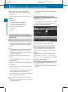
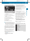
Bird’s-eye View:
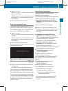
Map display : is oriented
in the direction into which you are heading;
the orange tip of the symbol points to the
North.
R
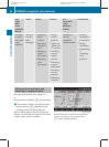
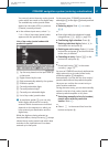
3-D Map: Certain buildings in selected
cities are displayed in detail as a 3-D (three-
dimensional) model. The map displays
mountains and valleys three-
dimensionally. The 3-D map is country-
specific and is connected with the function
City (3D) (Y page 92).
X
Selecting map orientation: Select Navi
Q Map Orientation.
The list of available map orientations
appears.
The
dot # indicates the currently
selected map orientation.
X
Select North Up, Heading Up, Bird's-
eye View, or 3-D Map and press W.
X
Exiting menu: Slide XVY.
Setting POI symbols
You can set which points of interest (POIs)
should be displayed as symbols in the map.
POIs
are
parking facilities, hotels, restaurants
or movie theaters, for example.
i
Depending on the map scale, POI symbols
may not be visible although their display is
activated. In addition, POI symbols may be
covered by other POIs or names displayed
on the map.
The following settings are possible:
R
Standard symbols (factory setting)
R
Personal symbols (you can select the
desired POIs)
R
No symbols
X
Adjusting:
Select Navi Q POI Symbols
on Map.
The map display list appears. A dot #
indicates the current setting.
X
Select Standard symbols, Personal
symbols or No symbols.
If
you
select Personal symbols, the list of
POIs appears.
X
Switching POI symbol display on or
off: Select the desired POI.
The corresponding symbol displays are
switched on or off, depending on the
previous status. A checkmark indicates
which status is active. You can switch on
the symbol
displays for more than one POI.
i
The list shows all symbols that are
contained in the digital map across all
states (USA) and provinces (Canada). Not
all POIs
in all states (USA) or in all provinces
(Canada) are available, however. Certain
POI symbols may not be displayed on the
map, even if the symbol display is switched
on. You can use this list as a map legend.
The map legend also contains, in addition
to the POI symbols, the names of the POI
categories.
X
Exiting menu: Slide XVY or press back
button % in the center console
(Y page 75).
Selecting traffic symbols on the map
You can select what kind of traffic information
is displayed on the map (Y
page 126).
Selecting text information on the map
COMAND can display various text
information below the map:
R
Time of arrival and distance to destination
R
Current street
R
Geo coordinates
R
None
COMAND navigation (introduction)
91
Control systems
216_AKB; 3; 90, en-US
d2ureepe, Version: 2.11.8.1
2009-05-15T11:47:50+02:00 - Seite 91
Z