


44
Set a Waypoint
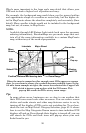
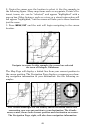
A waypoint is an electronic "address," based on the latitude and longi-
tude of a position on the earth. A waypoint represents a location, spot
or destination that can be stored in memory, then recalled and used
later for navigation purposes. You can create a waypoint at the cursor
position on the map or at your current position while navigating. You
can create a waypoint at any location by manually entering the posi-
tion's latitude and longitude. You can copy waypoints from your unit to
your personal computer with MapCreate software. When you want to
repeat a trip, these archived waypoints can be reloaded into the GPS
unit.
To create and save a Waypoint:
Two of these techniques use the Quick Save method, the fastest and
easiest way to create a waypoint.
NOTE:
The Quick Save method uses the default waypoint symbol until you
edit an existing waypoint and change its symbol. (Edit Waypoint
Symbol is described in Sec. 4.) After you have changed a waypoint
symbol, the unit will remember the one you chose and use it the
next time you "quick save" a waypoint. To revert back to the default
symbol, edit a waypoint and choose the original symbol, or use the
Reset Options command (described in Sec. 5).
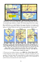
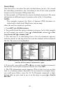
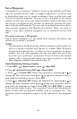
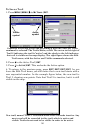
Create Waypoint by Entering a Position
1. Press WPT|→ to SUBCATEGORY column|↓ to NEW|ENT.
2. Press ↓ to
ENTERED POSITION|ENT|→ to CREATE|ENT.
3. Press → to
LATITUDE|ENT. Enter the latitude by pressing ↑ or ↓ to
change the first character, then press → to the next character and re-
peat until the latitude is correct. Press
ENT.
4. Press ↓ to
LONGITUDE|ENT. Enter the longitude by pressing ↑ or ↓ to
change the first character, then press → to the next character and re-
peat until the longitude is correct. Press
ENT, then EXIT|EXIT to return
to the previous page display. The waypoint is saved and automatically
given a name with a sequential number, such as "waypoint 001." The
waypoint symbol and number appear on the map and in the waypoint
list.