


36
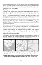
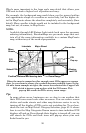
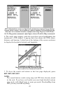
What's more important is the large scale map detail that allows your
GPS unit to show a higher level of position accuracy.
For example, the background map would show you the general outline
and approximate shape of a coastline or water body, but the higher de-
tail in MapCreate shows the shoreline completely and accurately (finer
detail). Many smaller islands would not be included in the background
map, but are, of course, in MapCreate.
NOTE:
Available through LEI Extras (look inside back cover for accessory
ordering information), FreedomMaps are pre-made maps that con-
tain all of the same information available in a custom MapCreate
map, without any of the work of preparation.
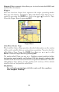
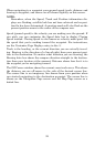
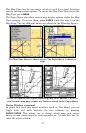
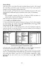
When the map is zoomed out far enough, most POIs appear as square
dots. As you zoom in closer, the symbols become readable icons. In the
0.2 mile zoom example at right, the cursor has selected the Cupps Café
POI, which triggers a pop-up box with the POI name. This
pop-up box works on POIs at any zoom range.
Tip:
In some urban areas, businesses are so close to one another that
their POI icons crowd each other on-screen. You can reduce screen
clutter and make streets and other map features easier to see by
turning off the display of POIs you're not watching for. To see how,
check the text on Map Detail Category Selection, page 83. It shows
how to use the Map Categories Drawn menu to turn individual POI
displays off and on. Even though their display is turned off, you can
still search for POIs and their icons will pop-up when your unit
finds them for you.
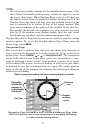
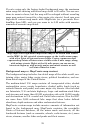
School POI
POI
Pop-up
Restau-
rant POI
POI
Marker
Position, distance and bearing data
Cursor line
Interstate
Major Street
Minor
Streets
Zoom Range