


34
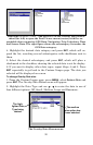
The Navigation Page has its own menu, which is used for some ad-
vanced functions and for setting various options. Options and setup are
discussed in Sec. 5. To access the Navigation Page Menu, from the
Navigation Page, press
MENU.
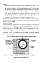
Map Page
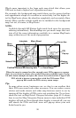
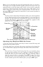
The Map Page screens show your course and track from a "bird's-eye"
view. By default, this unit shows the map with north always at the top
of the screen. This can be changed. See the topic Map Orientation, in
Sec. 5. If you are navigating to a waypoint, the map also shows your
starting location, present position, course line and destination. You
don't have to navigate to a waypoint, however, to use the map.
Map Page is the default screen that appears when you turn on the unit.
To get to the Map Page from another page: Press
PAGES|→ or ← to
MAP|EXIT. When the Map Page is displayed, a screen similar to the fol-
lowing figures appears.
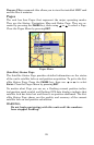
The arrow in the center of the screen is your present position. It points
in the direction you are traveling. The solid line extending from the
back of the arrow is your plot trail, or path you've taken.
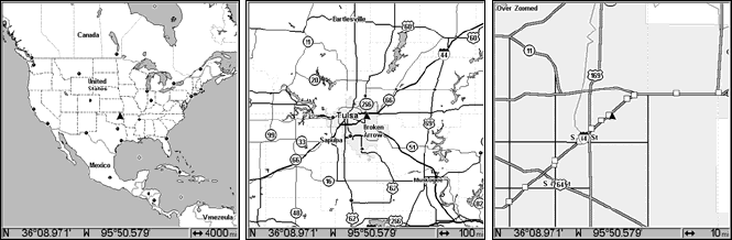
The map zoom range is the distance across the screen. This number
shows in the lower right corner of the screen. In the first of the follow-
ing example figures, the range is 4,000 miles from the left edge of the
map to the right edge of the map.
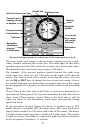
The Zoom In and Zoom Out keys zoom the map to enlarge or reduce its
coverage area and the amount of mapping detail shown. There are 39
available map zoom ranges, from 0.02 miles to 4,000 miles.
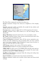
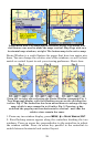
Far left, Map Page opening screen. Center, zoomed to 100 miles and
right, zoomed to 10 miles. Over Zoomed means you have reached the
detail limits in an area covered only by the basic background map.
Zooming in any closer will reveal no more map details because a high-
detail custom map has not been loaded on the MMC for this area.