


Garmin G1000 Cockpit Reference Guide for the DA40/40F
10-11
SECTION 10 – HAZARD
AVOIDANCE
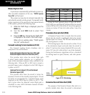
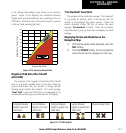
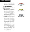
to be closing (descending) upon terrain at an excessive
speed. Figure 10-16 displays the correlation between
height above terrain and descent rate, resulting in the two
EDR alerts. EDR alerts have two levels of severity, caution
(sink rate) and warning (pull-up).
5000
4500
4000
3500
3000
2500
2000
1500
1000
500
0
2000 4000 6000 8000 10000 12000
"PULL UP""
P
U
L
L
U
P
"
"
S
I
N
K
R
A
T
E
"
Descent Rate (FPM)
Height Above Terrain (Feet)
Figure 10-16 Excessive Descent Rate
Negative Climb Rate After Takeoff
Alert (NCR)
The purpose of the Negative Climb Rate After Takeoff
alert is to provide suitable alerts to the pilot when the
system determines that the aircraft is losing altitude
(closing upon terrain) after takeoff. The aural message
“Don’t Sink” is given for NCR alerts, accompanied by an
annunciation and a pop-up terrain alert on the display.
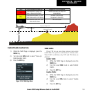
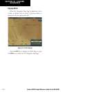
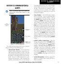
Unlighted Obstacle
(Height is less than
1000’ AGL)
Lighted Obstacle
(Height is less than
1000’ AGL)
Unlighted Obstacle
(Height is greater than
1000’ AGL)
Lighted Obstacle
(Height is greater than
1000’ AGL)
Potential Impact Points
Figure 10-17 TAWS Symbols
“Five-Hundred” Aural Alert
The purpose of the aural alert message “Five-hundred”
is to provide an advisory alert to the aircrew that the
aircraft is five-hundred feet above terrain. When the
aircraft descends within 500 feet of terrain, the aural
message “Five-hundred” is heard. There are no display
annunciations or pop-up alerts that accompany the aural
message.
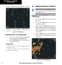
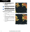
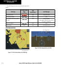
Displaying Terrain and Obstacles on the
Navigation Map
1) With the Navigation Map displayed, press the
MAP
Softkey.
2) Press the
TERRAIN
Softkey. Terrain and obstacle
proximity will now be displayed on the map.