


Garmin G1000 Cockpit Reference Guide for the DA40/40F
10-1
SECTION 10 – HAZARD
AVOIDANCE
SECTION 10: HAZARD AVOIDANCE
10.1 CUSTOMIZING THE HAZARD
DISPLAYS ON THE NAVIGATION MAP
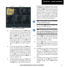
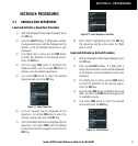
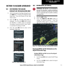
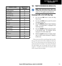
1) With the Navigation Map Page displayed, press
the
MENU
Key to display the Navigation Map
Page Menu. The cursor flashes on the ‘Map
Setup’ option.
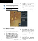
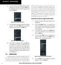
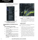
2) Press the
ENT
Key. The Map Setup Menu is
displayed. Turn the small
FMS
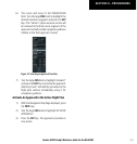
Knob to select
the ‘Weather’ or ‘Traffic’ group to customize
the display of weather features. Select ‘Traffic’
to customize the display of traffic.
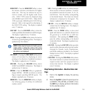
3) Press the small
FMS
Knob to return to the
Navigation Map Page.
Figure 10-1 Page Menu
Figure 10-2 Map Setup Menu
Figure 10-3 Map Setup Group List
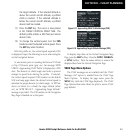
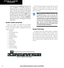
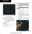
10.2 XM WEATHER (OPTIONAL)
WARNING: XM Weather is not intended to
be used for hazardous weather penetration.
Weather information provided by XM Radio
Service is approved only for weather avoidance,
not penetration.
1) Press the
MAP
Softkey.
2) Press the
NEXRAD or XM LTNG
Softkey to
display the desired weather. Press the
applicable softkey again to remove weather
data from the Navigation Map Page.
Figure 10-4 Navigation Map Page Displaying NEXRAD Weather
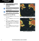
Displaying METAR and TAF information on the
Airport Information Page
Display METAR and TAF text on the Airport
Information Page:
1) Turn the large
FMS
Knob to select the WPT Page
Group.
2) Turn the small
FMS
Knob to select the Airport
Information Page.