


Garmin G1000 Cockpit Reference Guide for the DA40/40F
10-6
SECTION 10 – HAZARD
AVOIDANCE
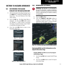
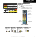
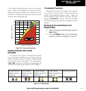
Traffic out of
range
Traffic 1600’ above &
climbing, moving in the
direction of the line
Traffic Mode
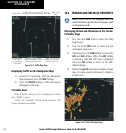
Figure 10-8 Traffic Map Page
Proximity Traffic at same
altitude, level flight & moving
in the direction of the line
Traffic Advisory, aircraft is 400’ above &
descending, moving in the direction of the line
Last data update
is older than 6
sec. resulting in
Coast mode
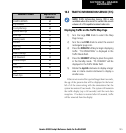
Displaying Traffic on the Navigation Map
1) Ensure TIS is operating. With the Navigation
Map displayed, press the
MAP
Softkey.
2) Press the
TRAFFIC
Softkey. Traffic will now be
displayed on the map.
TIS Audio Alert
When a Traffic Advisory (TA) is displayed, an audio
alert “Traffic” is given.
“Traffic Not Available” will be heard whenever TIS
service becomes unavailable.
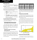
10.4 TERRAIN AND OBSTACLE PROXIMITY
NOTE: Terrain data is not displayed when the
aircraft latitude is greater than 75 degrees north
or 60 degrees south.
Displaying Terrain and Obstacles on the Terrain
Proximity Page
1) Turn the large
FMS
Knob to select the Map
Page Group.
2) Turn the small
FMS
Knob to select the last
rectangular page icon.
3) If desired, press the
VIEW
Softkey to access the
ARC
and
360
Softkeys. When the
ARC
Softkey
is pressed, a radar-like 120° view is displayed.
Press the
360
Softkey to return to the 360°
default display.
4) Rotate the
Joystick
clockwise to display a larger
area or rotate counter-clockwise to display a
smaller area.
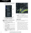
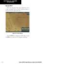
Figure 10-9 Terrain Proximity Page