


Garmin G1000 Cockpit Reference Guide for the DA40/40F
10-2
SECTION 10 – HAZARD
AVOIDANCE
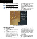
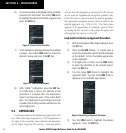
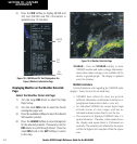
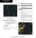
3) Press the WX Softkey to display METAR and
TAF text (METAR and TAF information is
updated every 12 minutes).
Figure 10-5 METAR and TAF Text Displayed on the
Airport (Weather) Information Page
METAR
Text
TAF
Text
WX
Softkey
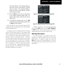
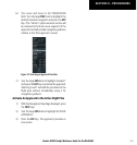
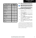
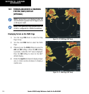
Displaying Weather on the Weather Data Link
Page
Select the Weather Data Link Page:
1) Turn the large
FMS
Knob to select the Map
Page Group.
2) Turn the small
FMS
Knob to select the fourth
rectangular page icon.
3) Press the available softkeys to select the desired
XM weather product.
4) Press the
LEGEND
Softkey to view the legends
for the selected products. If necessary, turn the
FMS
Knobs to scroll through the list. Press the
small
FMS
Knob or the
ENT
Softkey to return
to the map.
Figure 10-6 Weather Data Link Page
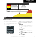
NEXRAD – Press the NEXRAD Softkey to show
NEXRAD weather and radar coverage information.
Areas where radar coverage is not available will be
shown in grayish-purple. The display is updated
every five minutes.
NEXRAD Limitations
Certain limitations exist regarding the NEXRAD radar
displays. Some, but not all, are listed here:
• NEXRAD base reflectivity does not provide
sufficient information to determine cloud layers or
precipitation characteristics (hail vs. rain, etc).
• An individual NEXRAD site cannot depict high
altitude storms at close ranges, and has no
information about storms directly over the site.
• The resolution of displayed NEXRAD data is 4
square kilometers. Therefore, when zoomed in on
the display, each square block is 2 kilometers on
each side. The intensity level reflected by the square
will be the highest level sampled within the square
area.