


Garmin G1000 Cockpit Reference Guide for the DA40/40F
10-7
SECTION 10 – HAZARD
AVOIDANCE
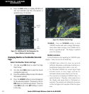
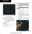
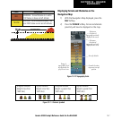
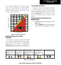
Color Indication
RED
WARNING: Terrain/Obstacle at or within
100’ below or above aircraft altitude.
YELLOW
CAUTION: Terrain/Obstacle between 100’
and 1000’ below current aircraft altitude.
1000'
Aircraft Altitude
100' Threshold
Unlighted Obstacle
(Height is less than
1000’ AGL)
Lighted Obstacle
(Height is less than
1000’ AGL)
Unlighted Obstacle
(Height is greater than
1000’ AGL)
Lighted Obstacle
(Height is greater than
1000’ AGL)
Figure 10-11 Obstacle Symbols
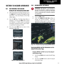
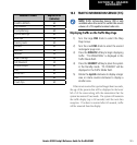
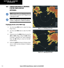
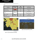
Displaying Terrain and Obstacles on the
Navigation Map
1) With the Navigation Map displayed, press the
MAP
Softkey.
2) Press the
TERRAIN
Softkey. Terrain and obstacle
proximity will now be displayed on the map.
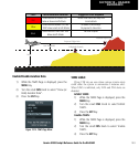
Maximum
elevation of
topography presently
displayed on-screen
Minimum
elevation of
topography presently
displayed on-screen
Ground elevation
at present aircraft
position
Aircraft altitude
Figure 10-10 Topography Scale
Range of
topography eleva-
tion presently dis
-
played on-screen