


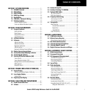
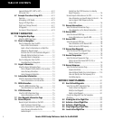
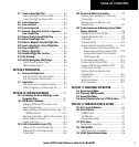
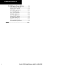

Garmin G1000 Cockpit Reference Guide for the DA40/40F
1-4
SECTION 1
SYSTEM OVERVIEW
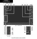
(16) ENT Key – Accepts a menu selection or data entry.
This key is used to approve an operation or complete data
entry. It is also used to confirm selections and information
entries.
(17) Dual ALT Knob – Sets the selected altitude in the
box located above the Altimeter. The large knob selects
the thousands, while the small knob selects the hundreds.
Altitude Select is used by the Automatic Flight Control
System in certain modes, in addition to the standard
G1000 Altitude Alerter function.
(18) AP Key – Engages/disengages the autopilot and flight
director. Pressing the AP Key activates the flight director
and engages the autopilot in the default pitch axis and roll
axis modes. Pressing the AP Key again disengages the
autopilot and deactivates the flight director.
(19) FD Key – Activates/deactivates the flight director
only. Pressing the FD Key turns on the flight director in
the default pitch axis and roll axis modes. Pressing the
FD key again deactivates the flight director and removes
the command bars, unless the Autopilot is engaged. If the
autopilot is engaged, the FD Key is disabled.
(20) NAV Key – Selects/deselects the Navigation mode.
(21) ALT Key – Selects/deselects the Altitude Hold
mode.
(22) VS Key – Selects/deselects the Vertical Speed mode.
(23) FLC Key – Selects/deselects the Flight Level Change
mode.
(24) HDG Key – Selects/deselects the Heading Select
mode.
(25) APR Key – Selects/deselects the Approach mode.
(26, 27) NOSE UP/NOSE DN Keys – Controls the
active pitch reference for the Pitch Hold, Vertical Speed,
and Flight Level Change modes.
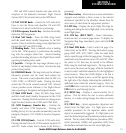
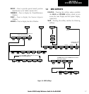
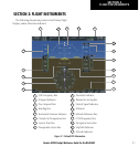
1.2 PFD SOFTKEYS
Softkey OFF
Softkey ON
OBS
TMR/REF
NRST
INSET
IDENT
XPDR
CDI
PFD
ALERTS
ADF/DME
(optional)
Figure 1-2 PFD Top Level Softkeys
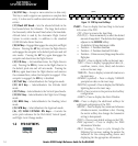
INSET – Press to display the Inset Map in the lower
left corner of the PFD.
OFF
– Press to remove the Inset Map.
DCLTR
(3) – Press momentarily to select the desired
amount of map detail. The declutter level appears
adjacent to the DCLTR Softkey.
• No declutter: All map features are visible
• Declutter – 1: Declutters land data
• Declutter – 2: Declutters land and SUA data
• Declutter – 3: Removes everything except the active
flight plan
TRAFFIC
– Press to display traffic on the inset map.
TOPO
– Press to display topographical data (i.e.,
coastlines, terrain, rivers, lakes) and elevation
scale on the inset map.
TERRAIN
– Press to display terrain information on
the inset map.
NEXRAD (optional)
– Press to display NEXRAD
precipitation data on the inset map.
XM LTNG (optional)
– Press to display the XM Radio
lightning data on the inset map.
BACK
– Press to return to the previous level softkey
configuration.
ALERTS
– Press to display the Alerts Window.
PFD – Press to display the additional softkeys for
additional configuration of the PFD.
METRIC
– Press to display the current and reference
altitudes in meters, in addition to feet. Pressing
the metric softkey also changes the barometric
setting to hectopascals.
DFLTS
– Press to reset default settings on the PFD.
DME
(optional) – Press to display the DME
Information Window.
BRG1 (bearing)
– Press to cycle through the
following Nav sources, making the pointer the
indicator for the corresponding source and
displaying the the appropriate information.