


Reference
39
Info Pages
Pressing MENU twice displays the Info menu items (GPS Info, Map Info, and System Info). From the
Main Menu window, you may select the following:
GPS Info page - Visual reference of GPS receiver functions
Map Info page - Displays version and map name(s) for any MapSource CD-ROM data stored on an
installed CF data card.
System Info page - Displays the unit software version and unit ID number.
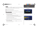
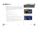
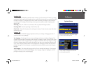
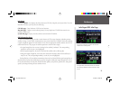
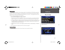
GPS Information Page
The GPS Information page provides a visual reference of GPS receiver functions, including current
satellite coverage, receiver status, and position accuracy. As the StreetPilot 2610/2650 locks onto satellites,
a signal strength bar appears for each satellite in view, with the appropriate satellite number (from 01-32)
underneath each bar. The progress of satellite acquisition is shown in three stages:
• No signal strength bar: the receiver is looking for the satellite(s) indicated. The corresponding
number(s) on the sky view is not highlighted.
• Hollow signal strength bar: the receiver has found the satellite and is collecting data.
• Solid green signal strength bar: the receiver has collected the necessary data and the satellite(s) is
ready for use. The corresponding number(s) on the sky view is highlighted.
Each satellite has a 30-second data transmission that must be collected (hollow signal strength bar, as
described above) before that satellite may be used for navigation (solid green signal strength bar). Once a
fi x has been calculated, the StreetPilot 2610/2650 then updates your position, ground track, and ground
speed by selecting and using the best satellites in view.
A hollow bar indicates the receiver has found the
satellite and is collecting data.
Solid green bars indicate the receiver has collected
the necessary information and the satellite is ready
for use.
Info Pages/GPS Info Page
2610_2650 OM.indd 39 8/1/2003, 4:16:05 PM