


Reference
13
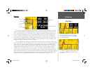
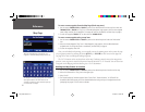
City Tab — Controls the display of different size cities on the map.
Area Tab — Controls the display of rivers, lakes, parks, and other areas (airports, shopping malls, hospi-
tals, etc.).
Some map data is only visible at certain zoom scale ranges. For example, you may set ‘Street Label’ Max
Zoom to 200 miles, but they would not show above a 0.8 mile zoom scale. Setting the Max Zoom to ‘Auto’
generally gives the best display performance.
Resetting Map Setup Defaults
You may reset (restore) map settings for each individual setup tab or for all tabs.
To reset map setup defaults:
1. From the Map Page, press the unit or remote MENU key.
2. Select ‘Map Setup’.
3. To restore defaults for an individual map setup tab, highlight the tab and press the unit or remote MENU
key.
4. Select either ‘Reset Settings’ or ‘Reset All Settings’.
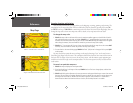
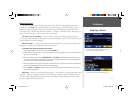
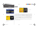
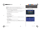
Tab Setup — Data tabs on the Map page display a variety of information and may be customized. You
can change the size, type of data displayed, shading of the data fi elds, and which tabs are shown/hidden.
There are two different sets of tabs that display, depending your navigation mode. When not navigating a
route, the ‘Mapping’ tabs are used and ‘Routing’ tabs are used while navigating a route.
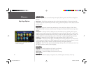
To show/hide individual or groups of data tabs (Touch screen only):
1. From the Map page, TOUCH the individual tab to hide it. The tab is replaced by a blue placeholder on
the right side of the display. TOUCH the placeholder to show the tab again. A tab turns red when it is
selected.
2. To show/hide more multiple tabs, TOUCH and hold on the left side of the topmost group of tabs you
wish to hide, hold and slide your fi nger in a ‘L’ shape down and right to the side of the display. Repeat
the process in reverse to redisplay the tabs.
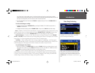
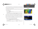
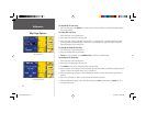
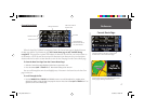
A series of “fi le tabs” allow you to change the Map
page setup options.
You can adjust the map colors for day or night
operation for maximum clarity.
Map Page Options
2610_2650 OM.indd 13 8/1/2003, 4:15:47 PM