


1-45
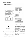
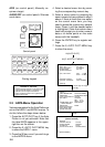
Note: Set and drift correction is available
on selecting the water tracking mode only.
Proceed as follows to enter set and drift
(rate):
1. Press the RADAR MENU key on the
plotting keyboard to show the FUNC-
TIONS 1 menu.
2. Press the [8] key to select menu item
8; SET, DRIFT.
3. Further press the [8] key to select OFF
or MAN option.
OFF: No correction against set and
drift.
MAN:Manual entry of set and drift data.
4. If OFF is selected, press the ENTER
key.
5. If you have selected MAN in step 3
above, the highlight cursor will advance
one line down requesting you to enter
SET xxx.x°. Enter the value of set in
degrees by hitting numeric keys with-
out omitting leading zeroes, if any, and
press the ENTER key.
The highlight cursor will then advance
to the next line DRIFT xx.x KT. Enter
the value of drift in knots by hitting nu-
meric keys without omitting leading
zeroes, if any, and press the ENTER
key. Set and drift have the same effect
on own ship and all targets.
6. Press the RADAR MENU key to close
the menu.
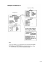
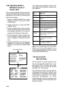
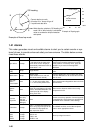
1.40 Display of Ancillary
Information
Wind and tide data and depth sounding
data can be displayed in the text cell which
is normally used to indicate third target
ship data. Do as follow:
1. Press the NAV MENU key to show the
NAV INFORMATION 1 menu.
2. Press [8] key twice to set WIND DATA
ON and press the ENTER key.
3. Press [9] key twice to set WIND
GRAPH ON and press the ENTER key.
4. Do the same to indicate ocean current
graph and echo-sounding chart. Depth
scales can be selected among 10, 20,
50, 100, 200 and 500 m on the NAV
INFORMATION 2 menu.
5. Press [0] key twice to show the NAV
INFORMATION 3 menu.
6. Press [2] key twice and press ENTER
key to select UTC.
Note: Wind data current data require the
respective sensors. The depth data re-
quires an adequate echo-sounding equip-
ment. The echogram shows the last 30
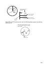
minutes of depths along the ship's track.
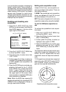
Wind vector shows a direction from which
the wind blows in, relative to own ship
heading, and labeled T*. Wind velocity is
a true wind speed as a result of compen-
sating for own ship's speed and orienta-
tion. Ocean current (tide) is the direction
to which the current is flowing away from
os position, relative to north.
*T in this case means a true value mean-
while T denotes "relative to True North"
in the case of EBLs and target ship vec-
tors.