


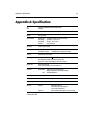


Appendix A: Specification A-1
Appendix A: Specification
CE Conforms to 89/336/EEC(EMC), EN60945:1997
Y2K Compliant
Size 184mm (7.3in) x 168mm (6.7in) x 75mm (3in), excluding trunnion
Weight 0.75 kg (1.65 lb)
Environmental Waterproofing To CFR46; suitable for external mounting
Temp Range Operating: -10°C to 70°C
Temp Range Storage: -20°C to 70°C
Humidity 20% to 95% RH
Mounting Trunnion (yoke) or panel
Power Input 10.0Vdc to 18.0Vdc 12Vdc nominal
Consumption - Typical <9.6W @12Vdc including GPS or dGPS
Controls 6 defined keys and trackpad
Display type Film Super Twist Neumatic
(FSTN) LCD
320 x 240 pixels (¼VGA) monochrome portrait with
4 grey scales, 4 levels of backlighting, 16 levels of contrast
Display size 145mm (6in) diagonal
117mm (4.25in) x 88mm (3.5in) viewable area
Interfaces Power/NMEA NMEA 0183 receive and transmit
Waypoint upload/download (WPL and RTE)
GPS GPS/dGPS
**
**
* antenna
Position data GPS (RC420), dGPS
**
**
* (RC420D)
Cartography Navionics Microchart cartridge
Software update Via Cartography cartridge interface
Memory Capacity: Waypoints: 500 max
(20 routes of up to 50 waypoints)
Track history: 2000 points
Protection: Built in Lithium battery giving 3 to 5 years usage
* Differential GPS